"Lesser men limp, weakly following in paths blazed by others. A strong man takes."
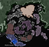
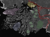
Sanardu
Sanardu, the walled city, the greatest city, city of elves, a snake's lair. The center of the world so far as the average (and the wealthy, and the poor) Fuvurian is concerned. An economic policy that mimics mercantilism results in the city overflowing not only in wealth, but in an excess of food, of raw materials, of manufactured goods. A majority of people who live and work in Sanardu are tradesmen, government officials, people who offer services or sailors. The rest are the backbone of society: farmers, fishermen, cleaners and so on.
The
red on the map indicates the Red Gate. The southernmost entrance into the city, it is tucked away behind cliff faces on either side. Anyone who tried to take the city by storm from the south would be bombarbed on three sides from above, faced with a gate that takes issue with trying to be dismantled.
The
purple on the map indicates the outer walls, the outermost limits of the city itself. To the north, farmland and the ruins of Sanardu lie past the outer walls, not indicated on the map.
The
blue is the inner wall, built in an early version of a concentric castle style. Whereby there is one outer wall, and an inner wall. In the event the outer wall is breached, the city still stands, with another layer of defence just as tough as the first.
The
light green is the inn Smoke's Reprieve, while the
dark green is the colloquial center of the city, their largest fountain.
Orange indicates the Last Gate. The last and smallest gate from which people can defend a piece of the city- the noble quarter- before fighting is taken to houses and on stairs. The
yellow and
pink gates are the inner and First Gate respectively.
The
odd bluish color indicates the Last Tree. The only tree from Riseport which took to the soul in the new lands. Smaller and more diminshed in this new land, it serves as a testament to the last Fuvurian capital.
The
dark blue is the docks. They don't have a fancy name, they are just "the docks."
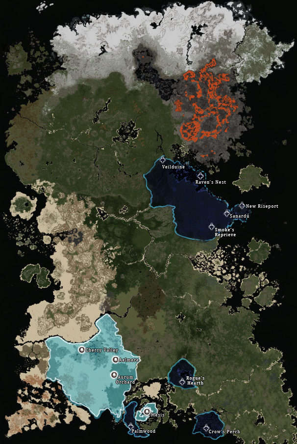
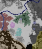
Bay of Folly
The most important individual colony of House Fuvur's, due to providing the sugar necessary for the city's mass production of rum. The entire bay is not claimed by the House Fuvur, but this is mainly because it isn't desirable. Beside for the largest island where the colony of Palmwood is situated, the rest of the bay is all but impossible to navigate due to the prevalence of sand bars and stony outcroppings amidst the islands. Hence, undesirable for trade by sea, and hence - Bay of Folly.
The
blue is the southern, very fertile, half of the main island. It is known as The Crescent.
Mountains are outlined in
red, known in the bay as Spines, due to the shape and form of the mountains.
Purple indicates uninhabited, small islands that, for whatever reason, just haven't been settled on in any major way. They are called Barrier Islands.
The center of the strangely shaped islands is known as The Eye, but mainly referes to the small island in the middle and the two islands either side of it. It is in
dark purple.
The
green coast along the bay is known as Smuggler's Coast, because while major trade ships can't navigate the treacherous bay, smaller ships such as those used by smugglers certainly could.
Orange indicates a strange sandy not quite a sand bar that is present even at high tide. This peculiar landmark is known in official records as Harateth's Scorn for some reason.
The Choking Estuary
A much more minor colony that serves mainly as a small trading village and a naval base from which Fuvurian ships restock before making the long voyage from Palmwood along the coast to Sanardu. The name comes from the fact that the mouth of the river has so many deltas that it is veritably choking on them, making trading by barges on the river a hard task and further limiting the wealth of the region.
Variclav Isle is outlined in blue, the second largest delta on the river and the only one that is inhabited by people.
Fat Whale is indicated by the
purple outlining a delta in the shape of a fat whale.
Light green are a strange rock formation known as Giant's Toys, because they look like the broken toys of a giant.
Dark green indicates another, larger rock formation that vaguely remembles a crumbling, short rise from Riseport. Its name is The Broken Rise.
Yellow indicates the delta I Don't Remember. Named because I don't remember why I had it highlighted.
The river itself is named Ava, in respect to the Lady of House Variclav. It's
red.
The Southern Deadlands
(former wise empire)
A region generally considered unstable by the people back in Sanardu, due to how recently it's come into the fold. Many nobles still haven't actively proclaimed union with House Fuvur, and it remains to be seen if some of the settlements currently being recorded will remain or secede in the wake of the recent proclamation. The region itself lacks in natural resources but for those exotic ones traded by the Soolerans in the region and produced in the few proper cities, such as Aelmere.
The river is outlined in
blue, and known as Thirst in Fuvurian records. North of this river is the rest of the desert, known as The Northern Deadlands, shockingly enough.
The
green indicates a region known as The Fertile Hills.
The
black mountains which indicate one edge of the boundaries of the deadlands are known as The Black Mountains, because the stone on them is a peculiar black color that is seemingly not coal.
Outlined in
red are a region of mountains known as Bilworth's Shoulders.
The
purple color is a strange geological formation of plateaus called The Steps.
Light blue indicates strange spires, known as Spires.
Brown indicates the Bay of Sand, while the
yellow indicates the Bay of Folly.